22/03/2020
- How can I extend a term license?
- Can I change a single licence for portable (USB) licence?
- How can I install a single licence?
- What is a term licence?
- I have lost (destroyed) the pendrive used to install the licence. What should I do?
- Can I change a single licence for portable (USB) licence?
- Why is it necessary to wait 24 hours to move the single licence from one computer to another?
- How to move the single licence from one computer to another?
- Can I install a single licence on a server?
- On how many computers can I install a single licence?
- I have lost (destroyed) the pendrive used to install the licence. What should I do?
- Do I need to have my own pendrive to install the software?
- What is the function of a pendrive in a portable (USB) licence?
- What do I need to install and activate a portable (USB) licence?
- Can I use a portabale USB licence on more than one computer at the same time?
- Problems with retaining the current position arrow and compass
- How to display a map from DXF file
- Measurement setup – antenna height, count of epochs, point name and code, etc.
- How to display an online map from WMS, WMTS, TMS, Google Maps or Open Street Map services
- Connection of the GNSS receiver with the QuickGNSS app
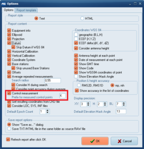
Comparison of source coordinates with measured coordinates
|
RawGNSS generates, by default, a comparison of source coordinates with measured coordinates.
Source coordinates are taken from the RAW/RW5 file. If there are no source coordinates in the RAW / RW5 file, you can load the external coordinate file. For this purpose, it is necessary to have at least a free version of the GeoView program, which can be downloaded from www.cubicorb.com.
The RawGNSS program compares points with the same numbers. In the measurement file the points (measured by the control) should contain a suffix (Note: capitalization matters!)
Select Tools -> Options…. In section Control measurement enter the suffix for control points. Select File -> Attach source coordinates… to attach source coordinates. After refreshing the report, the RawGNSS program automatically generates a comparison of source coordinates with coordinates from the measurement.